After an early start we had a pleasant 14-hour sail in light winds for the 65 miles from Tazacorte in La Palma to Puerto de la Restinga in El Hierro, arriving in time for a sundowner in the cockpit.

Sailing route to El Hierro
On the way we were overtaken by Tjakko and Iris Wielinga on Elusion. They took a photo of Island Drifter – before turning up the revs on their “iron genoa” and disappearing ahead of us towards La Restinga.
 Island Drifter on a beam reach flying its lightweight genoa
La Restinga is one of only two viable ports for yachts on the island. Situated at the eastern end of the south-west coast, it is well protected from the prevailing northerly winds. The port itself has two massive outer breakwaters and an inner mole to try to protect against reflected swell. It is now, with its two new pontoons, a good all-weather harbour that welcomes visiting yachts (of which there are only four at the moment). Even the Al-Cor security guard, Jose, was all smiles!

La Restinga port from the north

Local inshore fishing boats on pontoon in La Restinga
The port was originally constructed as a refuge for fishermen working south in the inhospitable waters of the Atlantic. Even today, a large orange search and rescue craft is based in the port. Towards the end of our time in La Restinga four offshore fishing boats from other ports pulled into the harbour to avoid a southerly gale.
 |
| Offshore fishing boats from Tenerife sitting out a gale on the quay under the breakwater |
The huge east breakwater is appliquéd with some interesting art deco motifs, reminiscent of icing designs on a child’s birthday cake.

Art deco motifs on inside of the breakwater at La Restinga
The adjacent village is small and pleasantly arranged on the hill behind a promenade overlooking the harbour. A couple of restaurants, a bank, self-catering apartments and a dive shop are situated along the seafront. Come siesta time, it could almost be called a ghost town. Then the only things moving fast are little flocks of turnstones dashing about the promenade and the lava shoreline.

Village of La Restinga viewed from across marina

One restaurant claims to be
the most southerly bar in Europe!
The village is normally a quiet backwater surrounded by a couple of extinct volcanoes and lava fields. These are quite varied and include some unusually smooth lava coiled like ropes. In other places tunnels have formed, a few being large enough to walk through underground.

Coiled pillow lava
In November 2011, however, an underwater volcano along a fault line erupted 2 kilometres south of La Restinga, where we are currently based. The village was evacuated for a period. In the village there is now an information office that has excellent photos and videos of the eruption.

The sulphur gas-ball at an early stage of the underwater volcanic eruption off La Restinga in November 2011

Subsequent underwater volcanic action that continued for four months after the eruption (note La Restinga in the background, only 2 kilometres away)
For over four months, pyroclastic rocks were to be found floating in the sea, at first steaming hot. The white porous centres slowly became waterlogged and the “bombas” (volcanic Maltesers?) sank to the seabed. These were named “Restingalites” after the nearby village of La Restinga.
 |
Steaming rocks (still at 400°C) being collected
by lifeboat in metal mesh nets
|
Beyond La Restinga the south coast to Punta Orchilla is steep and virtually uninhabited, with only one small anchorage at Bahía Naos – where anchoring by yachts is prohibited!

Uninhabited south coast of El Hierro looking from the east
Dive boats are, however, permitted to anchor or take a buoy and the coast is said to offer some of the best diving in the Canaries. Six dive centres are located in La Restinga. Divers, yachtsmen and hikers appear to be the village’s principal visitors. Mike managed to make three dives, one with a group of Russians from a neighbouring charter yacht. Unfortunately Helen’s finger hadn’t healed sufficiently for her to risk immersing it but she enjoyed riding in the dive boat at 25 knots per hour!

Underwater photo of Mike giving the “OK” signal

Close encounter with a “friendly” Moray eel
For many centuries Punta Orchilla was considered (by Europeans) to be the limit of the “known world”. During the fifteenth century it was also noted that the island had a zero magnetic variation. No doubt for both these reasons Punta Orchilla, the island’s most south-westerly point, was chosen by Spain in 1634 as a prime meridian, one of several at the time. It relinquished its status in 1884 with the international recognition of Greenwich.
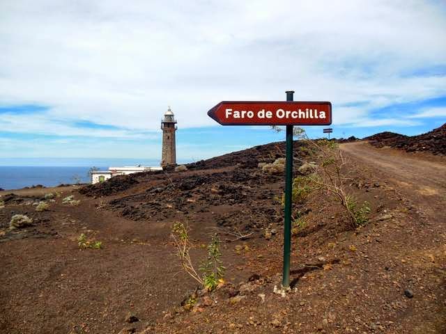
Lighthouse at Punta Orchilla, a prime meridian until 1884 when Greenwich took over

Monument to Punta Orchilla’s historic status
as a prime meridian
Punta Orchilla is also the official end of the GR131 hiking trail, which runs from one end of the Canaries archipelago through each island in the Canaries to the south-west extremity of El Hierro.

End of GR131 hiking route in the Canaries
El Hierro is the most south-westerly of the Canary Islands and is the smallest, most remote, tranquil and unspoilt of them. It is also the least visited since the island finds it difficult to accommodate cruise liners and it is too far from Tenerife for day visitors by ferry.

Map of El Hierro
Since the bus services radiate out from Valverde, the capital at the other end of the island, and are not that frequent, we hired a car together with Tjakko and Iris. Each couple had use of it on alternate days. A good arrangement, giving a “rest day” in between driving days.

HCN – the nearest Helen is going to get
to a personalised number plate!
Many of the secondary roads have to wind round the steep slopes of the island. They cling to the contours with grim determination.

Secondary road clinging to the contours

Roads have to wind their way around the steep slopes
Compressed lava tracks usually connect small hamlets and houses to the main and secondary road system. We used these, although we were probably not insured to do so. Our most notable “off road” experience was when we drove to the juniper forest in the south-west corner of the island and in particular to “El Sabinar” – an ancient juniper tree, the emblem of the island. (There is nothing wrong with the tree in the photo; it’s simply that this type of tree survives by submitting to the wind and leaning its branches on the ground to stabilise itself.)

Typical dirt track (this one is actually quite wide!)
 |
| El Sabinar, an ancient juniper tree, emblem of the island |
The distinctive features of Canary landscape are all present in El Hierro: mountain forests; volcanic badlands; extinct caldera; smallholdings; banana plantations; and colourful colonising shrubs. All that’s lacking are sandy beaches that are the focus of tourist development on the other islands – although there are a few good, small black sand beaches.

Laurisilva cloud forest

Canary pines growing at top of the caldera rim

Colourful primo-colonising shrubs
taking root in the lava and ash
The island is self sufficient for power with a hydroelectric scheme augmented by wind power. (There is also a diesel generator for emergency use.) While there is plenty of natural water on El Hierro, much of which is collected in small reservoir, the supply nevertheless has to be supplemented by a desalination plant at each port.

Photo of hydroelectric power system information board
About 11,000 people live on the island. It is said that they have no wish to be swamped by tourists and are content for their island to remain a tranquil haven for “discerning” travellers (us?).

Government Parador in attractive location with good beach on east coast. One of only two large hotels on island

Typical saltwater swimming areas built along the rocky coast in absence of sandy beaches
Being only 278 sq kms in area, yet rising to 1500 metres, El Hierro changes very rapidly from coastline to coastline and at different altitudes. A central ridge runs in a long semicircle around the north-west bay of El Golfo – the remaining rim of an extinct volcanic crater, the rest of which slipped into the sea some 50,000 years ago.

Photo of signboard showing El Golfo caldera rim
and GR131 route

El Golfo caldera from the south
Exposed to the Atlantic swell as it is, the rocky coast of El Golfo is inhospitable to yachts but the wide coastal plain is the garden of El Hierro where bananas, pineapple, vines and tomatoes are grown. The local wine from the Frontera district is very drinkable.

One of many small pineapple fields in the El Golfo valley
At the Mirador de la Peña, at the north end of the caldera rim, is a restaurant and viewpoint created by the Lanzarote architect and artist Caesar Manrique. The restaurant is built into the cliff and overlooks the El Golfo bay. One can stand on their external balcony from where the cliff drops a sheer 1,000 metres below one’s feet down to the shore.

View of El Golfo caldera and the town
of Frontera from the north

1000m drop from the Mirador de la Peña to the shoreline
Many of the islanders live by farming smallholdings or by fishing. Besides cereals and potatoes there are many fruit trees, also almonds and figs, the latter being exported to the other islands where they are held in high regard. When a fishing boat comes back into La Restinga, one can nip round to the quay and buy fresh fish.
 Young figs, not yet big enough to harvest
El Hierro cheese is made from a combination of cow, goat and sheep’s milk and comes in a variety of types – fresh, smoked, cured and spiced. They are all delicious.

Local cheese and wine
The capital of the island, Valverde, is no bigger than a small town. It has hardly been affected by tourism. Its street plan is said not to have changed since Columbus called in on his second Atlantic crossing. (It seems that he “called in” everywhere although there is no hard evidence to support some of these claims!) While in the days of pirate raids the Canary capitals were usually sited in the hills away from the coast, Valverde is these days the only one not located at a sea port.
Valverde, the only Canary Island capital sited inland:

Viewed from Island Drifter

Viewed from the south
The east coast is very steep and open to the prevailing north-easterly wind. Puerto de la Estaca is, however, situated in a protected bay. It is relatively close (9 kms) to the capital, Valverde, and is the island’s car ferry (and occasional small cruise liner) terminal. Nearby is the small airport which services turbo-prop flights from the other Canary Islands.

The ferry port of Puerto de la Estaca
viewed from north
The inner harbour for small craft in the port is well protected. Unfortunately it is full of local boats on fore and aft moorings. This leaves little room to manoeuvre. Visiting yachts are, however, allowed to berth against the inner harbour walls. Anchoring in the harbour is not permitted.

The inner harbour of Puerto de la Estaca
To the north of Puerto de la Estaca, the old fishing port and now small holiday village of Tamaduste has a very interesting natural harbour. Unfortunately, although the water is deep at the centre, the bar across the entrance is too shallow to allow yachts in!

Tamaduste’s interesting little natural harbour
There are two other interesting anchorages on the east coast, south of Puerto de la Estaca. Bahía de Tijimiraque, only a kilometre to the south of the port, is a deeply indented bay with a small sandy beach formerly used as a refuge by local boats in strong southerly winds. Five kilometres further south lies an even more sheltered bay, Bahía de Bonanza, with its arched rock – Roque de la Bonanza (Fair Weather Rock). The bay inside the rock is calm in northerly winds even when there may be breaking waves only 200 metres offshore to the east.

The very protected bay with sandy beach
at Bahía Bonanza
We delayed our departure from El Hierro so that we could watch some traditional Canary wrestling in a dedicated indoor arena in El Piñar, the village 15 kms north of La Restinga. We were the only tourists! The rest of the audience were family and supporters from the two villages participating in this team sport. It was conducted with “Japanese” style respect for officials and the other team. The aim is to get one’s opponent off balance so that he touches the sand floor with any part of his body (with the exception, of course, of his feet).
 |
Traditional Canary wrestling
Before leaving La Restinga, Mike and Tjakko had time to hire diving equipment so that we could both clean the bottom of our boats and propellers prior to, in our case, returning to the UK.
|
 |
| Jumping into the marina in order to clean the hull |
We’re now beginning to plan our return to the UK. To an extent our route and timing will, of course, depend on the weather. Currently we’re thinking of going back to Lanzarote, to improve our sailing angle to the prevailing winds, before heading north, probably via Madeira, and then either on the Atlantic Route via the Azores or up the Portuguese coast and across Biscay to the UK.
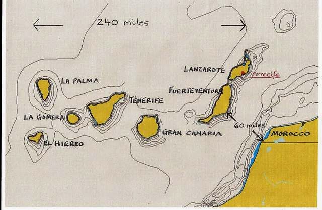 |
| Canaries Archipelago |
Fair wonds for passage back to the UK! Hans and Eli
ReplyDelete